And so it begins... As with every new year, millions of us vow to make ourselves better than we were the year previous. I am no different. Every year, the first days and weeks of January become loaded with ambitious "To Do" lists as long as one's arm, only to inevitably be cast aside or covered with dust due to the speed of life's pace. Each year, while I never complete every goal I write down to achieve during the year, I do manage to make myself a better person, and finally do some of the things that I've been wanting to accomplish for years. As I look back at 2011, it really is remarkable to see that growth that I've made in the last year, and I can't wait to make 2012 an even more productive, happy year.
Since it's been well over a year since I last wrote on here, it's easy to say that there's definitely room for improvement, and with this entry alone I'll eclipse my total contributions of all 2011. Let's celebrate! Believe me when I tell you that 2011 was the year that I grew closer to my family than ever before, and where my appreciations of the wonders of the world around me grew exponentially.
I've decided that I would play 'catch up' and share what made 2011 so amazing for me. The "Adam Awakening" ultimately began at the beginning of October of 2010 with the passing of Grandma Provance, and it is still rolling forward today. I gained a greater appreciation for life as a whole from that point forward. Shoot, it only took 33 years!
Here's a look at some of the places I visited, people I visited, and things I learned in 2011.
Trip to Arizona, March/April 2011
On a spur of the moment whim, I decided to pack my bags the last weekend in March and take a quick road trip down to Arizona. I was sick and tired of the cold, snowy, crummy weather that had enveloped Utah valley since mid November, and I'd been spending all those miserable days planning blissful, action packed trips for once it got warm. I couldn't wait any longer, so off I went to sunny AZ. I had been preparing this trip for May, but I was itching to get out. I went solo, which I had never done before, which may sound foolhardy, if not dangerous, but I know that I'm well versed in wilderness survival and always hike with a backpack with the essentials to allow me to survive days if not weeks if lost. (And yes, I saw 127 Hours. Great movie by the way.)
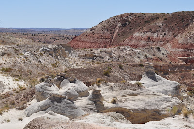
I took off and headed straight for the Rimrock Hoodoos, east of Kanab, UT. They aren't really well known, and it isn't too remote, and some of the pictures I had seen looked pretty nifty. I was NOT disappointed. Here are the views in and around Rimrock.
This is the view looking south into Arizona from the Rimrock Hoodoos.


The colors were AMAZING. I never knew rocks so close in proximity could be so different in color. Rich reds, bright whites, radiant oranges, and deep purples. Words and pictures don't do these colors justice. Gorgeous. After spending a couple hours at Rimrock wandering around, exploring, climbing, and in general feeling like a kid at a playground, I continued my adventure, crossed over Glen Canyon Dam which formed Lake Powell, and stopped at a little nondescript roadside parking area just south of Page, AZ, and sought out my next supreme vista. Horseshoe Bend overlooks the Colorado River which has carved out a horseshoe shape meander through the rock over thousands of years. It's a short hike to the edge from the parking area, and you can't even see this view until you come over a small crest of a hill, and BOOM! This is what greets you! From the top of the overlook, the cliffs drop over one thousand feet straight down to the Colorado. No handrails, nothing to block the view. It takes the breath away.
 |
| Horseshoe Bend |
 |
| Sitting on the edge of an 1100 foot drop straight down. This is one of those pictures you don't show Mom. |
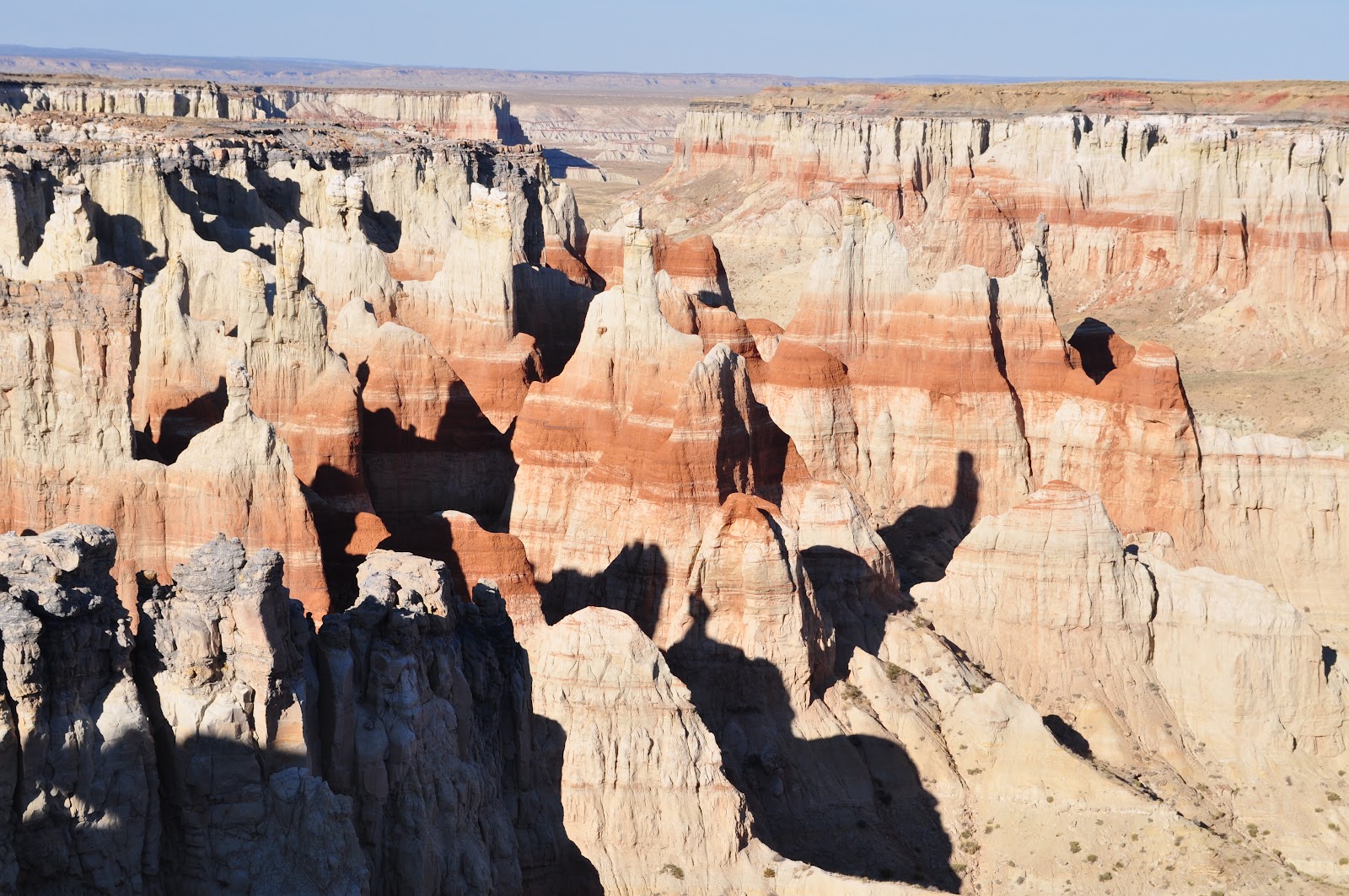
After calling Mom and Dad from Horsebend Bend, and telling them to look it up on Google Earth so they could see what I was currently looking at, I headed farther south, past Tuba City, AZ to one of my favorite places ever. A place that hardly anyone has ever visited. Coal Mine Canyon.
As expected, when I arrived at Coal Mine Canyon it was nearing sunset and I didn't see another soul. While it is way out in the middle of nowhere on Navajo and Hopi Indian reservations, I'm surprised more people haven't heard of it, and you know what? Fine by me.
 |
| I've been here three times. With the exception of my friend Justin that came here with me, I've never seen anyone else. |
 |
| Great vistas in all directions |
After spending the night in Tuba City, I went back to Coal Mine Canyon after sunrise, drove down old dirt roads that looked like they hadn't been used in decades. Very cool. Very quiet. The Grand Canyon National Park (South Rim) would be quite the opposite of where I'd just been.Before entering the National Park, I went to the Little Colorado River Gorge which was a pleasant surprise. It is very deep. Cliffs drop about 2000 feet straight down to the river below. Once again, I had the place all to myself. Upon entering Grand Canyon National Park, there were hundreds of tourists everywhere. Great views though.
 |
| Little Colorado River Gorge | | | | | | | | | | | | | | | | | | | | | | |
|
 |
| Some of the views at Grand Canyon National Park |


Trip to southern Utah - May 2011
I went to the North Rim of the Grand Canyon about five years ago with my family, but this was my first time to the South Rim. It was so much fun even though it was by myself. It's nice to travel as fast or slow as I wanted. I think that everyone needs some solitude, and for me, I can't think of a better place than the outdoors, enjoying the wonders of world around me. It was a great trip, and on my drive home, I was already looking forward to going my next adventure.
After just a couple weeks after my trip to the Grand Canyon, I was antsy for another weekend trip. So on the 1st of May, I left the snow covered mountains in Provo and headed south once again. I took off for a little known place called Willis Creek, and then to better known place called Bryce Canyon National Park. I took off early down to a Willis Creek, a very remote spot south of Cannonville. Down a sandy, dirt road for about 10 miles, in and out of various gullies I traveled until I arrived at the trailhead. Runoff from snowmelt in Bryce Canyon drains east into what forms Willis Creek. Seasonal flash floods have carved narrow passages through the rock as the creek eventually drains into Buckskin Gulch some 40 miles to the southeast. The water typically is only ankle to mid calf in depth and carries an orange hue from the sediment eroded from the hoodoos at Bryce Canyon. Willis Creek did not disappoint! The walls start only eight or ten feet high, but after just a half a mile, they soar to over 200 feet on both sides.
 |
| Entering Willis Creek Narrows |
 |
| One of my favorite shots during the hike! |
 |
| "Mr. Lizard" striking a pose. |
After Willis Creek, I headed to Bryce Canyon National Park. Even though I'd lived in Utah for ten years, I'd never made it down to see the famous colorful hoodoos. Boy, had I been missing out! It was amazing! If you've been there you know I what I mean! After taking a ton of pictures on the rim of Bryce Canyon, I dropped down into the hoodoos and hiked the Navajo Loop trail and the Queens Garden trail.
 |
| View from Bryce Point |
 |
| Along Queens Garden trail |
What a peaceful hike. This is a place that I definitely want to go back to and spend more time! So much to see.
I really loved these trees. Talk about the tenacity and persistence it took these trees to push higher, and straight as an arrow, despite being surrounded by walls hundreds of feet high.
It was like a wonderland being down among the hoodoos. I felt tiny! Here is a shot of a hoodoo called Thor's Hammer.
I was planning on spending two days down there, but I had seen more than I had expected, and as the sun started to set, I could see the storm front that had been forecasted, moving in from the west, so I decided to call it a day, and enjoy a relaxing day home, basking in the beauty of what I had just hiked through.
About two weeks later, I went back down to what had become one of my favorite places in southern Utah, the Grand Staircase - Escalante National Monument, only this time I brought friends. I had the week off work, and had planned two separate trips down to Escalante. During the first half of the trip, Jeniel Lovell, and her roommate Katherine came down with me. We headed back to Provo on Wednesday, and then early Thursday, I headed back down there with my regular hiking friend, Melissa Richardson, to hike down there until Sunday. I don't know how I get so lucky, but the weather for all my trips have been perfect, and this one was no different. We ended up seeing some of the most beautiful places southern Utah has to offer! We visited Calf Creek Falls, Willis Creek, Golden Cathedral, Spooky Gulch, Peek-A-Boo Gulch, Brimstone Gulch, Devil's Garden, and perhaps my favorite place, Coyote Gulch.
This was the hike I was most looking forward to taking. It can be from a 15-35 mile hike, depending on how you drop into the gulch. There's several ways in, and I of course, decided to try the quickest, yet steepest and most dangerous way in. Most hikers prefer to enter Coyote Gulch from either end of the gulch, which runs about 35 miles one way. The advantage is that hikers begin hiking in the gulch while it's just a wash. Halfway from the ends of Coyote Gulch is the most beautiful part, it also where the sheer canyon walls soar 600 to 800 feet from the bottom of the gulch. I had read about a "sneaker trail" that is a two mile walk across open desert, and then down a steep 700 foot crack to the bottom of the gulch. It takes you right to the middle, most beautiful part of Coyote Gulch. When I got to the edge of the cliff and looked down where we had to downclimb, I was nervous that the girls would refuse to go down. It was a little intimidating, and we had no climbing gear, because I was told it wasn't necessary. But as it turned out, once I started heading down, it wasn't that bad, although, one slip and one could tumble a several hundred feet, so needless to say, I took my time and so did the girls. Once down in Coyote Gulch, the hike was incredible. A clear stream about a foot in depth ran the length of the gulch which would drain into the Escalante River, then into Lake Powell. Natural bridges, arches, waterfalls, and colorful desert varnish greeted us on our trip down Coyote Gulch. It was beautiful.
 |
| Jacob Hamlin Arch |
 |
| In Coyote Gulch |
 |
| One of my favorite shots of the trip. Looks like paradise to me! |
 |
| Cliff Arch seen in the middle of the picture |
 |
Coyote Natural Bridge |
 |
| Metate Arch, Devils Garden |
After the awesome hike through Coyote Gulch, we spent the next day visiting a place called the Golden Cathedral. What used to be a little known alcove that used to be a place for cattle to graze, has since become of the premier repelling spot for enthusiasts. At the end of one of the many side canyons along the Escalante River, lies this gem. Getting there required us to hike across open desert of four miles and then ford the cloudy Escalante four times to reach the side canyon hiding the Golden Cathedral. A two mile walk up the side canyon leads to what you see below. Very, very, cool!
 |
| I'm in the lower right corner, and you can see how huge it is. Those two holes are actually pothole arches that people can repel through, and during flash floods, a powerful waterfall storms through the bottom pothole. |
 |
| The Golden Cathedral |
Melissa and I also went to Lower Calf Creek Falls, which is about eight miles south of Boulder, UT. It is a leisurely three mile hike to the base of the falls that rushes over the top of an alcove at the end of Calf Creek Canyon. The colors of the algae on the rocks behind the waterfall have all the colors of the spectrum when it is in sunlight. After we went to Calf Creek Falls, we went to Willis Creek Narrows. Even though I'd just been there a couple of weeks before, I wanted to go back, mainly because I enjoyed so much the first time!
 |
| Lower Calf Creek Falls |
 |
| Hiking through Willis Creek |
 |
| I love the striations in the rock |
 |
| While Melissa and I were in there, the water actually rose about six inches in less than 20 minutes due to a storm 50 miles away. |
On the ride home, I once again couldn't help but start thinking about what I would see on my next trip down to southern Utah. Each time I go down there, I find four or five other places that I have to add to my list of things to see down there. Not a bad dilemma to have.
Trip to Kanab, UT, June 2011
About 47 miles east of Kanab, UT, is Buckskin Gulch, and at 23 miles is the longest slot canyon in the world. It had been a place I'd been researching and reading about for months. I had made plans for a group from Arizona to meet up at Kanab with a group I was coming down with and then hike Buckskin. Unfortunately, the Arizona group cancelled last minute, and I figured we'd postpone the trip, however I still decided to go down there by myself and see it for myself. It was another beautiful day and the temperature couldn't have been better. Since Buckskin Gulch is 23 miles long, and since the walls are several hundreds of feet high, it is a deadly place to be caught in a flash flood. An average of twelve flash floods rip through Buckskin each year. The walls vary from five feet apart to as much as 25 feet apart, so in some area of the slot, flash floods can reach up to 75 feet high, as evidenced by huge tree trunks that had been wedged high above between the canyon walls. It's also known for being home to rattlesnakes and scorpions.

Here are some of the rock formations located right at the beginning of the hike entering into the Wire Pass trailhead. As seen in the picture below, Wire Pass quickly tightens up as you approach Buckskin Gulch.
The picture below is one of my favorite pictures inside Buckskin Gulch. I'm not kidding when I say that I took nearly 750 pictures... just while I was inside Buckskin! The lighting was amazing and always changing. I pretty much snapped a picture every one hundred feet.
 |
| I loved the colors down there! |
This picture of me was taken about six miles into Buckskin. As you can see, the walls were constantly changing. Instead of being tight, narrow, and twisting, the walls were sheer vertical. This was the widest part of Buckskin Gulch, and it kind of gives you an idea how small you feel in there!
On the left is a picture of a tree trunk wedged against the walls from a recent flashflood. It looks like just a small tree branch, but it was a full grown tree trunk wedged about 75 feet overhead. In this portion of the canyon, that is how high the flash floods reach. Scary to think about! On the right is another shot of the high canyon walls.
Below is another one of my favorites. It almost looks like the walls are on fire and the flames are climbing up the canyon walls!
I didn't see a whole lot of people in there, but when I did, I tried to have them snap a couple of pictures regardless of whether it was a cool part of the canyon or not. As it turns out, I was lucky in this picture, it once again displays how tiny I am in there.
You can imagine my surprise when, in one of the tighter parts of Buckskin Gulch, at about eye level, I come across this Great Horned Owl just chilling on a rock. It was clearly a young owl, because I knew that Great Horned Owls grow to be one of the largest owls found in North America, and this was kinda small. Roofus, as I named him, was pretty relaxed with me, and let me get within three feet of him, but after seeing Roofus's rather large talons, I didn't want to press my luck any further.

In a long slot canyon like Buckskin Gulch, it is uncommon to see wildlife of any kind, especially since there are no substantial food or water sources. However, in a span of about fifteen minutes, I came across the Great Horned Owl, followed by a face to face encounter with the guy below. One thing about me, I am terrified of snakes! I've have a couple of close calls with rattlesnakes on hikes, and I've nearly been bitten a couple of times in places that were very remote, this one being no exception. Despite being terrified, I couldn't help but snap a picture of this guy. He was coiled up along the walls of one the most narrow sections of Buckskin Gulch. Luckily, there was enough room to squeeze by him without him getting all fired up.
 |
| As you can see, this Western Diamondback rattlesnake was not happy to see me... The feeling was mutual. |
After my amazing adventure in Buckskin Gulch, I had about an hour of daylight left of that perfectly clear day, and I decided to make a quick trip to the Paria Badlands, which are located just about ten miles north of Buckskin Gulch. After traveling down a dirt road for a couple of miles, you come around a bend in the road and bam! These are the views you get. Every color in the rainbow was there. It was breathtaking. This was also the site of hundreds of Western movies back in the day. I had the whole place to myself! Didn't see a soul the entire time I was in the Paria Badlands.
Below is my favorite picture of the Paria Badlands.
The next day, I took Cottonwood Canyon Road, a 47 mile dirt road that runs from Cannonville, UT to US-89 between Kanab, UT and Page, AZ. I decided to hike through Lick Wash, Cottonwood Canyon Narrows, Grosvenor Arch, and check out the Cockscomb, all located off side routes of Cottonwwod Canyon Road. The Cockscomb is actually a fault line where two continental plates have come together, pushing up millions of years of colorful rock. It was amazing to see so many colors jutting out along the fault line.
 |
| Grosvenor Arch in the upper left |
 |
| Grosvenor Arch upclose |
 |
| The Cockscomb along the fault line |
I think I've said this four or five times already, just about pictures from this trip, but the picture below is one of my favorites. Once again, I had the place all to myself. It was incredible.
 |
| The Cockscomb along Cottonwood Canyon Road |


Comments
Post a Comment